-
 The National Weather Service is encouraging people to prepare for scattered, potentially strong thunderstorms Monday afternoon and evening.
 -
 Heat advisory in effect from noon Monday until 7:00 p.m. Tuesday
 -
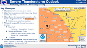 The greater threat for severe weather will be in the afternoon and evening on Wednesday.
 -
 Principal Kevin Kampmann hosted an all-school assembly to mark the milestone, saying everyone in the building has a lot to be thankful for
 -
 Wisconsin saw more severe thunderstorm, tornado and flash flood warnings in the first three weeks of April than in any other month in the last four decades of available data
 -
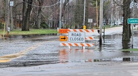
 A tornado damaged more than 140 homes in Marathon County Friday night
 -
 The latest report from the Wisconsin Initiative on Climate Change Impacts finds the 2010s were the wettest decade on record
 -
Major damage in the Marathon County Town of Ringle
-
 The Governor’s Office says storms began moving through the state on April 13th, bringing devastating winds, tornadoes, hail, and heavy rainfall
 -
 The decision comes as many locations around Wisconsin are dealing with the impacts of bad weather, leaving emergency management and first responders strained
© 2026 WXPR

Play Live Radio
Next Up:
0:00
0:00
Available On Air Stations


