-
 After shoveling 30 inches of snowfall from this past weekend, some people might find themselves needing medical attention
 -
 Major roads are much improved, but still snow covered in some locations
 -
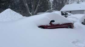 The blizzard still impacting Northern Wisconsin brought record snowfall totals to some areas, most to the south of Rhinelander.
 -
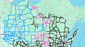 Travel is not advised for some roads in the Wisconsin Department of Transportation’s North Central Region
 -
 The entire state is under some kind of warning or advisory for the snowstorm that is forecasted for Saturday night through Monday afternoon.
 -
 Update: Historic totals of widespread 12–30"+ of snow likely, with the highest amounts north of HWY 29. Winds gusts 40–50+ mph will cause whiteouts and "near impossible" travel Sunday through Monday afternoon, according to the National Weather Service Green Bay.
 -
 A winter storm warning is in effect from 4:00 p.m. Tuesday, March 10 through 1:00 p.m. Wednesday, March 11 for Iron, Price, Vilas, Oneida, Forest, and Gogebic Counties.
 -
 The Department of Transportation warned earlier this month that they’d already recorded 13 plows hit by vehicles
 -
 Long before flashing lights, diesel engines, and steel blades scraping asphalt, winter travel in the Northwoods of Wisconsin was a slower, tougher proposition
 -
 Ongoing winds and snow could create additional outages
© 2026 WXPR

Play Live Radio
Next Up:
0:00
0:00
Available On Air Stations


